DepotEco Live Web Cam
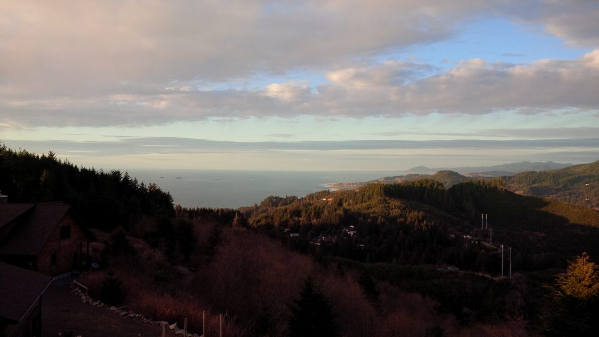
Looking north, over-looking Gold Beach Oregon and Cape Blanco Lighthouse
Live
Archive

I
DepotEco Live Web Cam
Looking north, over-looking Gold Beach Oregon and Cape Blanco Lighthouse
Live
Archive
Your cart is currently empty!
Notifications
41 responses to “Gold Beach Coast Web Cam”
HOT!!!!!!!!!!!!!!!!!!!!!!!!!!!!!!!!
UGGGGGGGGGGGGGGG …
Cold and foggy then Blazing hot..
OMG! talk about a View. MAN its Clear. I could see Ships in front of Santa Cruz Island… Looks like your rain washed the sky’s and maybe your camera 🙂 ..
Nice job. I love the Web Cam of the Santa Barbara Channel.
Are you sending low resolution picture now?
The picture looks fine to me.
And there is a yard powwow.
WE turn it up and down depending on the shot. Some times I crank it up to take stills of the Sunset.. But i turn it back down to conserve bandwidth.
OH yeah what a sunset. Please save a high resolution.
It must be really clear in the Santa Barbara Channel to see all those anchor lights at Santa Cruz Island. I had no idea there were so many boats out there. Have you estimated how many there are?
One of those anchor lights at Santa Cruz Island was me, I was watching me too. That was a little surrealistic. Sailing is a different world with internet.
webcam is not working again. please fix it again.
Yea it does that when Cox Cable disconnects the Business critical connection .. and trees fall :(..
Thanks for looking !!!
After installing Java for Chrome the web cam looks as good as ever on Google Chrome. So far the Depoteco store looks good too, both the DepotEco.com and the Amazon.com DepotEco stores. What are all those lights out by Santa Cruz Island at night? It is hard to tell if they are always there and hide in the fog or if they come and go?
Is the Santa Cruz Island web cam down?
Oh there it is, thank you.
We have moved to the Oregon South Coast. And Relocated out Coastal web cam. Now you can see the Oregon South Coast looking North to the city of Gold Beach and the Rouge River.
Major Wild Fire here on the Wild Rivers Coast. The Chectco Bar Fire Rages out of control.
https://inciweb.nwcg.gov/incident/article/5385/39218/
Chetco BarFire Update – August 28, 2017 9:00 a.m. (PST)
Weather and Fire Behavior: Critical fire weather conditions will continue today. Extreme fire behavior is anticipated. Dry and unstable conditions will lower humidity into the night and the unstable air could lead to more lift and ventilation over the fire. “This means people may see smoke columns forming,” said Noel Livingston, Incident Commander.
Yesterday: Chetco Bar Fire burned toward Hog Mountain to the northwest, Snow Camp Trailhead to the north and above Emily Creek to the south.
As smoke cleared in the afternoon helicopters dropped water to slow fire progression; helping firefighters who were working to hold fire within containment lines and build additional direct and indirect containment line.
Firefighters and heavy equipment worked to connect existing roads and dozer lines south and west of the fire. Crews also continued to assess buffer zones around houses and clear brush as needed to protect homes. They have moved into the Pistol River and Winchuk areas.
Due to very active fire behavior on the southwest side of the fire, Curry County Sheriff’s Office expanded and heightened evacuation levels for some residents. Evacuation information is online at https://inciweb.nwcg.gov/incident/5385/.
With 80 degree temperatures and 20% relative humidity, Chetco Bar Fire burned actively overnight and crews worked spot fires on the west and south perimeter.
Today: Firefighters will use an infrared heat sensing device to locate, then suppress hot spots near the fire’s perimeter. As visibility and weather conditions allow, helicopters and aircraft will drop retardant and water to help slow the fire’s spread.
Crews will continue to construct direct dozer and handline, install and maintain hoselays, and scout for opportunities to extend containment lines north and south of the fire. Planned containment lines incorporate existing roads, sparsely vegetated ridgetops, and previously burned areas, including the 2002 Biscuit Fire. A structure protection group will continue to reduce fuels surrounding homes, install and maintain hose lays.
Basecamps for Chetco Bar Fire will consolidate into a single location on Oceanview Drive.
Evacuations/Closure Information: is online at https://inciweb.nwcg.gov/incident/article/5385/39102
https://nifc.maps.arcgis.com/apps/MapSeries/index.html?appid=3a60cbe6fc654811a51bce3b66cad6eb
(A Chetco Bar Fire comprehensive blog has been developed that will provide fire and evacuation maps, fire updates, scheduled public meetings, national and regional fire links, air quality & information)
Later today, a strong high pressure front will move into the area. The resulting rise in temperatures, coupled with lower humidity and drying winds will increase fire activity. Fire could make its way to the tops of individual or groups of trees and potentially cast embers up to three-tenths of a mile, causing new ignitions (or spot fires). Temperatures will continue to rise this week and increases in fire behavior are anticipated.
#ChetcoBarFire
August 30: Daily Update, Air Quality Report and Map
Weather and Fire Behavior: Fog developed overnight and is expected to cover most of the lower elevations of the fire this morning. The resulting cooler temperatures and improved humidity recovery should moderate fire behavior.
Later today, a strong high pressure front will move into the area. The resulting rise in temperatures, coupled with lower humidity and drying winds will increase fire activity. Fire could make its way to the tops of individual or groups of trees and potentially cast embers up to three-tenths of a mile, causing new ignitions (or spot fires). Temperatures will continue to rise this week and increases in fire behavior are anticipated.
Yesterday: The fire was active on the north, south and east perimeter. It pushed several miles to the northeast into the area previously burned by the 2002 Biscuit Fire.
With improved visibility, each of the seven helicopters assigned to Chetco Bar was able to work the fire on Tuesday. On the southern flank, aircraft provided bucket drops in the Emily Creek area. Crews connected most of the contingency line on the southwest/west edge and have been searching for, and extinguishing, hot spots within 25 feet of the fireline. Indirect line construction occurred in the Pistol River area.
Over the course of the incident, Oregon State Fire Marshal crews have assessed 1,222 structures, completed preparation work on 532 structures, and set more than 500 sprinklers.
Today: National Guard firefighters are joining the effort. They will extinguish hot spots that could potentially threaten containment lines between the fire and Brookings. Firefighters will take advantage of the moderated fire behavior early in the day to construct line in advance of the coming weather. This effort includes fireline construction in the areas at risk near Emily Creek and Hog Mountain. Aircraft will assist crews on the ground as visibility permits.
Evacuations: Level 2 and 3 evacuations are in place in Curry County. They are being continually evaluated and adjusted to reflect developing conditions and resource availability. Residents are encouraged to monitor the Inciweb interactive evacuation map for changes. This map can be viewed at : https://nifc.maps.arcgis.com/apps/MapSeries/index.html…
Area Closure Information: Several large wildfires are burning in southwest Oregon. Area closures have been implemented on the Rogue River – Siskyou National Forest and BLM lands. Fire restrictions are in place.
More information https://inciweb.nwcg.gov/incident/article/5385/39248/
Download and print this update: https://inciweb.nwcg.gov/…/relate…/pict20170730-110739-0.pdf
Download and print this map: https://inciweb.nwcg.gov/…/…/2017_08_30-11.05.46.211-CDT.pdf
Almost didn’t find this way down here… https://www.windy.com/?rain,42.208,-124.003,8
Great site Tom! I posted a link at the top of the page!.
Chetco Bar Fire UPDATE:
The following information was issued at 12:30 p.m. today by the Oregon State Fire Marshal:
Weather and Fire Behavior: Fog developed overnight and is expected to cover most of the lower elevations of the fire this morning. The resulting cooler temperatures and improved humidity recovery should moderate fire behavior.
Later today, a strong high pressure front will move into the area. The resulting rise in temperatures, coupled with lower humidity and drying winds will increase fire activity. Fire could make its way to the tops of individual or groups of trees and potentially cast embers up to three-tenths of a mile, causing new ignitions (or spot fires). Temperatures will continue to rise this week and increases in fire behavior are anticipated.
Yesterday: The fire was active on the north, south and east perimeter. It pushed several miles to the northeast into the area previously burned by the 2002 Biscuit Fire.
With improved visibility, each of the seven helicopters assigned to Chetco Bar was able to work the fire on Tuesday. On the southern flank, aircraft provided bucket drops in the Emily Creek area. Crews connected most of the contingency line on the southwest/west edge and have been searching for, and extinguishing, hot spots within 25 feet of the fireline. Indirect line construction occurred in the Pistol River area.
Over the course of the incident, Oregon State Fire Marshal crews have assessed 1,222 structures, completed preparation work on 532 structures, and set more than 500 sprinklers.
Today: National Guard firefighters are joining the effort. They will extinguish hot spots that could potentially threaten containment lines between the fire and Brookings. Firefighters will take advantage of the moderated fire behavior early in the day to construct line in advance of the coming weather. This effort includes fire line construction in the areas at risk near Emily Creek and Hog Mountain. Aircraft will assist crews on the ground as visibility permits.
Evacuations: Level 2 and 3 evacuations are in place in Curry County. They are being continually evaluated and adjusted to reflect developing conditions and resource availability. Residents are encouraged to monitor the Inciweb interactive evacuation map for changes. This map can be viewed at : https://inciweb.nwcg.gov/incident/5385/